Newly mapped: Missoula megafloods sculpted eastern Washington landscape
(CN) — As glaciers receded and melted at the end of the last ice age, the Missoula megafloods cut a path across much of eastern Washington state, carving out an area now known as the Channeled Scablands.
Among the largest flooding events in recorded history, but until recently no one had mapped the course the Missoula megafloods took or the mark they left on the landscape. Prior to the floods, the weight of massive ice sheets deformed the Earth’s crust and caused large chasms through which the floodwaters would eventually flow.
Researchers from the University of California, Santa Cruz, describe how the increasing weight of the ice sheets reshaped the entire landscape and altered the course of the coming flood in a new study published Monday in the journal Proceedings of the National Academy of Sciences.
“People have been looking at high-water marks and trying to reconstruct the size of these floods, but all of the estimates are based on looking at the present-day topography,” said lead author Dr. Tamara Pico, assistant professor of Earth and planetary sciences at UC Santa Cruz, in an email. “This study shows that the ice age topography would have been different over broad scales due to the deformation of Earth’s crust by the weight of the ice sheets.”
At the time of the last ice age, vast sheets of ice covered much of the Northern Hemisphere and they didn’t begin to melt until around 20,000 years ago. Because of their immense weight, the ice sheets left impressions on the ground below in a process known as glacial isostatic adjustment — much like setting a heavy object onto a soft mattress — which remained indented long after the ice sheets began to melt. Those indentions helped funnel meltwater through the landscape and led to the Missoula megafloods between 15,500 and 18,000 years ago.
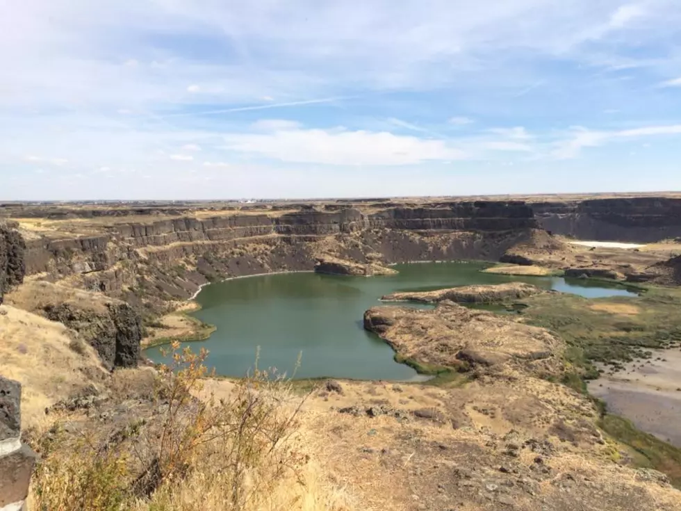
Pico and her team reconstructed these events to better understand how large-scale flooding can affect the landscape both on Earth and on Mars. They focused their efforts on the Channeled Scabland, a region where an ice-dammed Lake Missoula overflowed and led to dozens of megafloods across the snow-swept landscapes of Idaho and eastern Washington. The region now features deeply carved canyons and large tracts of land with scoured basalt and stream-lined loess deposits, which the authors say indicates intermittent flooding in the distant past.
“We used flood models to predict the velocity of the water and the erosional power in each channel, and compared that to what would be needed to erode basalt, the type of rock on that landscape,” Pico said.
Lake Missoula came into existence when a lobe of the Cordilleran ice sheet formed an impromptu dam blocking the Clark Fork valley in the Idaho panhandle, causing meltwater to accumulate behind it. As the water deepened, the ice dam began to float and the lake overflowed, leading to the subsequent floods. As enough water was released the ice dam once again settled into place and the process started over, continuing for thousands of years.
That same process repeated itself downstream. An ice dam on the Columbia River formed Lake Columbia and its flooding spilled over onto the eastern Washington plateau and created the Channeled Scablands. In their research, the authors focused on two major channel systems in the Scablands — the Cheney-Palouse and Telford-Crab Creek tracts.
“As the landscape tilted, it affected both where the water overflowed out of Lake Columbia and how water flowed in the channels, but the most important effect was on the spillover into those two tracts,” Pico said. “What’s intriguing is that the topography isn’t static, so we can’t just look at the topography of today to reconstruct the past.”
The study emphasizes the potential for glacial isostatic adjustment to inform the history of erosion for a given landscape, which then helps researchers determine past flood routing and the extent of ice sheets’ size and footprint.
“I was so excited when I first ran these simulations and saw that the floods took different pathways at different times,” Pico said. “It is very difficult to reconstruct the relative timing for when different channels flooded, and for me it was extremely exciting to see that ice age deformation was sufficient to control which paths the floods took at different times over the ice age. To even be able to make those kinds of predictions for flood routing felt like a big breakthrough!”