Granite Complex fires at Lolo Pass worsen while West Lolo improves
In what is turning into one of the worst fire seasons in decades, fire crews are managing to report some early successes. But they can never celebrate because other fires pop up that demand attention.
Over the weekend, the Lolo National Forest announced that fire crews had made enough headway on the West Lolo Complex northwest of Missoula that they could scale down the level of response. On Sunday, a Type 2 Incident Command team took over, releasing the Type 1 team to move on to more critical wildfires elsewhere.
Crews have managed to fully contain eight of the complex fires, leaving two fires to work on. Closest to Missoula, the Deep Lookout Mountain Fire grew almost 100 acres over the past week to 365. Crews have worked to contain almost 50% but the tough terrain is making full containment difficult. Today’s winds could push some of the smoke out but also cause the fire to flare in isolated spots.
The larger Thorne Creek Fire northeast of Thompson Falls is traveling along steep ravines so it grew 750 acres over the past week to almost 1,700. Due to its location in the steep, rugged terrain of the Cube Iron/Silcox area, it poses an extreme risk to firefighter safety so fire managers are using more of an indirect strategy of watch-and-wait and take action when opportunity presents itself.
It was four years ago today that Missoula firefighter Trenton Johnson died of a tree strike while fighting the Florence Fire and fire managers want to reduce the chances of losing another life.
Farther south, the four fires of the Granite Complex near Lolo Pass have increased to more than 1,700 acres since it began a week ago and there is zero containment. Fire managers are most concerned about keeping the fires west of U.S. Highway 12 so the highway can stay open.
The Lolo Creek fire is the closest to the highway and poses the most risk. Fire behavior specialist Dan O’Conner said the trees species there, including subalpine fir and lodgepole pine, have branches that extend to the ground, so flames can climb the trees, causing torching that can throw firebrands if winds get higher. During Sunday, the fires grew by 400 acres.
As a result, California Interagency Incident Management Team 15, a Type 2 team, took over management of the fires on Sunday morning. Deputy Incident Commander Tom Clemo thanked the outgoing Type 3 team and the Lolo community.
“We want to thank the team before us. They did an excellent job of setting us up for success on this incident,” Clemo said Sunday. “We also want to thank the town of Lolo that’s been a wonderful host to us, including the school where we’re running our command post right now.”
All crews are watching this afternoon with some dread. While the National Weather Service predicted the cloud cover would hold daytime temperatures down to the upper 80’s instead of Sunday’s high of 99, a red flag warning is issued until 9 p.m. in the east and west Lolo and Bitterroot fire zones.
Thunderstorms bearing lightning but little if any moisture will pass through, and the gusts from their passage could reach between 25 and 50 mph. Lightning and high winds can be a deadly combination for wildfires. The winds could cause the fires of the Granite Complex to push through some of the drainages.
Fire behavior specialists say the threat could remain through Wednesday.
“In this country, (fire movement is) slow and steady. But when it gets an opportunity, it’s going to push upslope. If it’s got some winds, if it’s able to breathe, this fire will move around. It’s not going to slow down, only speed up when it has that support,” O’Conner said.
The Missoula County Sheriff’s Office has issued an evacuation warning from Lolo Hot Springs to the Idaho border, meaning that an evacuation order is likely imminent and residents need to be ready to move out quickly.
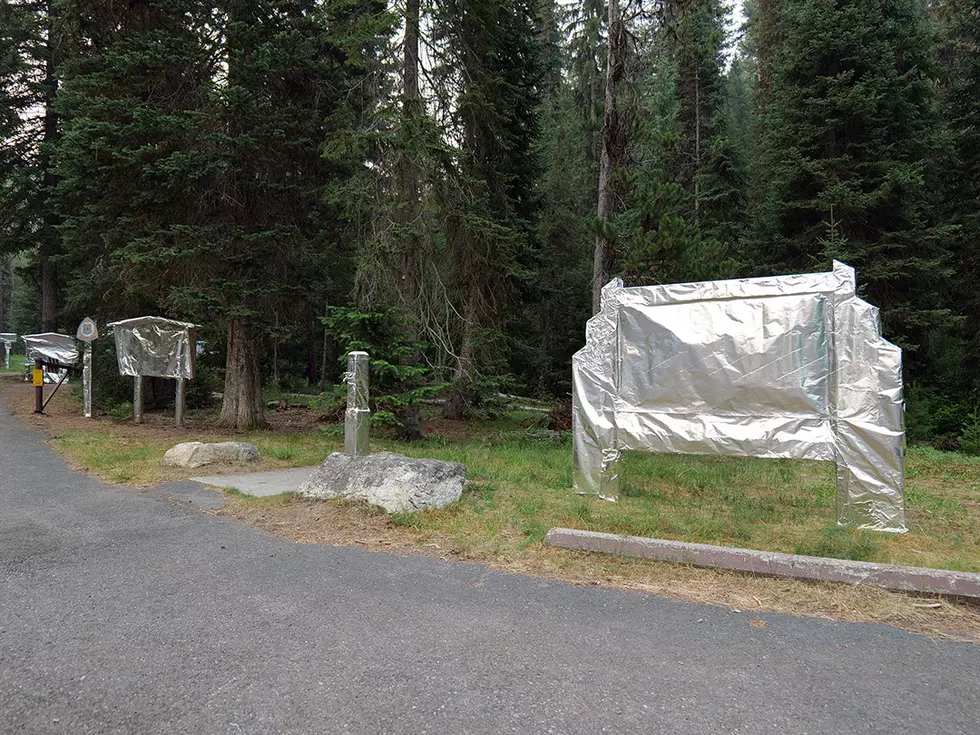
The Lolo Pass Visitor Center and Lee Creek Campground are closed.
On Thursday, as a precaution, firefighters completed wrapping recreation sites, including kiosks, signs, picnic tables, footbridges and other recreation infrastructure primarily in the Lee Creek Campground. Wrapping involves putting a fire-resistant shield around structures to protect them from embers, heat and potential flames.
For the safety of fire crews, the speed limit has been dropped to 45 mph on Highway 12 from Spring Gulch to Lolo Pass.
The Granite Complex Team has introduced the public to the Haines Index, a rating from 2 to 6 that indicates how hot, dry, and windy weather conditions will be near an active fire. Monday was supposed to be a 6, the worst.
That’s not surprising considering how dry fuels are this year in Montana. Last week, Philip Higuera, professor of fire ecology at the University of Montana, told NBC Montana that fuel moisture levels that are drier than they've been in the last decade and are much drier than they were at this point in 2017, the most recent bad fire year around Missoula.
"What concerns me right now is seeing how dry these fuels are and how long this fire season looks to be. We have the real potential for record-setting fires, not so much in areas burned but for interacting with humans,” Higuera told the network. "I'm paying a lot of attention to red flag warnings. I don't necessarily want to be out in the woods or in an area where I might not be able to escape if a fire were to occur.”
In addition to the Brewster Fire near Rock Creek east of Missoula, another fire dubbed the Anderson Hill Fire started on Thursday near Garnet Ghost Town and has grown to more than 600 acres. The Bureau of Land Management has closed all BLM land in the southwest portion of the Garnet Mountains north of Interstate Highway 90, including the ghost town.
A Type 3 Incident Command Team took control on Saturday morning. The fire grew quickly, burning in thick timber and the steep, rugged terrain adds to the incident’s complexity.
A cold front predicted for Wednesday evening into Thursday is supposed to bring slightly cooler temperatures to the region but also gusty winds.
Contact reporter Laura Lundquist at lundquist@missoulacurrent.com.